INSPIRE
INSPIRE (Infrastructure for Spatial Information in Europe) establishes the general rules for the establishment of a Spatial Information Infrastructure in the European Community based on the Member States' Infrastructures. It was adopted by the European Parliament and the Council on 14 March 2007 (Directive 2007/2/EC). Its purpose is to make relevant, concerted and quality geographic information available in order to enable the formulation, implementation, monitoring and evaluation of policies with an impact or territorial dimension of the European Union.
To ensure that Member States' spatial data infrastructures are compatible and interoperable in an EU and cross-border context, the Directive requires the adoption of common Implementing Rules specific to the following areas: metadata, datasets, network services, monitoring and reporting. Some of these rules are European Commission Regulations and are therefore mandatory in each EU country. The technical implementation of these standards is carried out through Technical Guidelines, technical documents based on international standards and norms.
The transposition of the Directive at national level was carried out through Law 14/2010, of 5 July, on geographic information infrastructures and services in Spain (LISIGE), which incorporates Directive 2007/2/EC into the Spanish legal system for its compliance and includes the establishment of the Geographic Information Infrastructure of Spain. This guarantees the integration of the set of geographic information infrastructures and interoperable geographic information services under the responsibility of the Spanish Public Administrations. Among its tasks is the creation of the Board of Directors of the Geographic Information Infrastructure in Spain (CODIIGE) where one of its main objectives is to adopt the Regulations establishing the INSPIRE technical specifications corresponding to the interoperability of geographic data and geographic information services and to monitor their compliance.
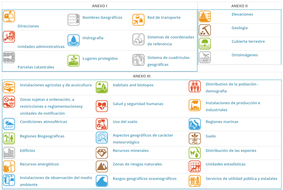
In terms of datasets, the Directive defines 34 thematic areas, prioritised in 3 annexes, for which implementing rules and technical guidelines were developed that Member States have to use to adapt their datasets to European requirements and avoid duplication. It is very important to stress the importance of knowing that INSPIRE does not demand the production of new geographic data, it is not a production initiative, but does require from the Member States the adaptation of their national data according to its standards.

Thematic areas of INSPIRE
In particular, land occupation is divided into two INSPIRE themes:
- Annex II, theme 2, Land Cover (LC): Physical and biological cover of the land surface, including artificial surfaces, agricultural areas, forests, natural or semi-natural areas, wetlands and water bodies.
- Annex III, theme 4, Land Use (LU): Characterisation of the territory, according to its functional dimension or its planned current or future socio-economic use (e.g. residential, industrial, commercial, agricultural, forestry, recreational).


