Production methodology
The SIOSE polygons divide the territory geometrically into homogeneous land occupation in terms of cover and land use, while the assignment of thematic class information is done in accordance with the SIOSE object-oriented data model.
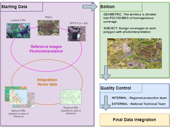
Production is carried out in a decentralised manner in each Autonomous Community, divided into different phases to achieve a homogeneous final product for the entire national territory (2005-2014 versions).

Outline of production methodology
-
Collection of reference information
- SPOT5 satellite image as geometric and temporal reference and Orthophotographs of the National Aerial Orthophotography Plan (PNOA).
- Databases of Boundary Lines between Autonomous Communities of the Central Registry of Cartography of the IGN.
- Larger scale Land Occupation Databases provided by the Autonomous Regions (multi-scale integration).
- Reference Geographic Information produced by the IGN on the following subjects: Transport Network, Hydrography Network and Populations.
-
Exogenous supporting information (integration)
- Landsat 5 TM images
- Orthophotographs and/or satellite images provided by the Autonomous Regions, previously approved by the National Project Management.
- National Topographic Base (BTN25).
- Cadastre
- Geographic Information System of Agricultural Plots (SIGPAC).
- Forestry Map of Spain (MFE) and Map of Crops and Uses of Spain (MCA).
- Databases and thematic maps relating to land occupation provided by the Autonomous Regions, previously approved by the National Directorate of the Project.
-
Production phase
Once the information has been compiled and integrated, the Autonomous Community Production Teams carry out the following tasks:
- Geometric editing of the SIOSE polygons. This consists of digitising the SIOSE polygons by photo-interpreting the images and integrating the reference and support information using GIS software and tools.
- Thematic editing. This is the assignment of percentages of classes and attributes following the SIOSE data model contained in each digitised polygon.
All the information corresponding to SIOSE is registered by means of its corresponding metadata.
-
Quality control
- Internal quality control. This is carried out by the Autonomous Community Production Team to ensure that the data produced has the required geometric, semantic and topological quality.
- External quality control. This is carried out by the National Management of the project on all the databases produced by Autonomous Communities, so that each one can guarantee the homogeneity and accuracy of the final product.
A topological and general control of the database is carried out (coherence of the database, control of minimum units according to type of cover, the non-existence of corridors or polygons attached with equal cover, etc.), as well as a geometric control to ensure adequate adjustment to the reference images and a semantic control to determine the quality and reliability of the photo-interpretation.
-
Integration of databases at the national level
After the production phase by the Autonomous Community Production Teams and the corresponding quality controls, the National Project Management generates a single, continuous and uniform geographical database for the entire national territory, without obvious geometric or semantic mismatches between neighbouring Autonomous Communities.
-
Field verification
In addition, for SIOSE2005, field observation work was carried out with the aim of checking and resolving doubts about photo-interpretation, as well as obtaining an album of GPS geo-referenced photographs uniformly distributed throughout the national territory.

Example of a 360° panoramic view of the Autonomous Community of Castilla y León


