SIOSE Label
SIOSE polygons are associated with one or several combined presences of covers or uses, with their percentage of occupation and a series of attributes depending on their type.
This information on the covers, uses, percentages and attributes present in the polygons is collected in an orderly manner in alphanumeric tables, but also appears in a descriptive code called SIOSE label, in the geometry tables within the SIOSE_CODE field.
SIOSE AR label
Covers
The covers label of each geometry is defined within the field LABEL in the table T_POLYGONS. They are represented by a label consisting of three capital letters referring to their name, as indicated in the cover tables of the document: "SIOSE AR Cover, Uses and Attributes Tables" in the field "LABEL".
Each label is accompanied by a value between 1-100 that indicates the percentage of occupation of the cover in the polygon.
- In the case of a single cover per polygon, the label shows no percentage value, as it is assumed to be 100% occupation.
- In the case of more than one cover, each label is preceded by the value of its percentage of occupation in the polygon.
- In addition, if there is more than one cover, they are written in order from highest to lowest percentage value and separated by underscores ("_").
- Grassland Scrubland
SIOSE label= PMT
EXAMPLE 2. Several covers in the same polygon:
- 76% Paved or Sealed Areas.
- 24% Building.
SIOSE Label= 76PAV_24EDF
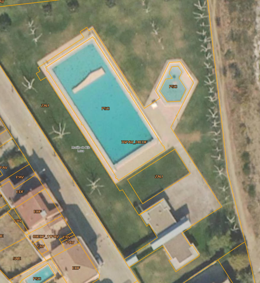
Example Simple and Composite SIOSE AR Cover
Attributes
When covers have attributes, these are represented by a label consisting of two lower case letters following the cover to which it is assigned, as indicated in the attribute tables of the document: "SIOSE AR Cover, Uses and Attributes Tables" in the field "LABEL".
Only affirmative or certain attributes, for which information is available in each cover geometry, are indicated. If a cover has more than one attribute, one will appear one after the other:
EXAMPLE 1. One single cover and attribute:- Dry-farmed vineyard
SIOSE label= LVIsc
EXAMPLE 2. Several covers with different attribute:
- 87% Irrigated vineyard
- 13% Rainfed vineyard
SIOSE label= 87LVIrr_13LVIsc
EXAMPLE 3. More than one attribute per cover:
- 100% "bank formation" and "in plantation" trees.
SIOSE label= ARBfrpl
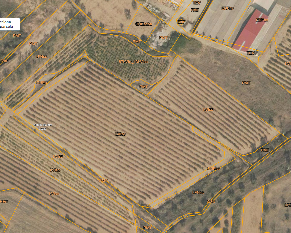
Example Single and Composite Cover with attributes SIOSE AR
Uses
The use label on each parcel is defined in the field LABEL in the table T_USES. These uses are represented by a label consisting of five capital letters referring to their name, as indicated in the USES tables of the document: "SIOSE AR Cover, Uses and Attributes Tables" in the field "LABEL".
- These labels are preceded by the value of their percentage of occupation in the polygon. The percentage can have 3 digits.
- The combination of several uses can add up to more than 100%. This is because, especially in urban environments, the percentage of occupation of each use is determined by the built-up area according to the Cadastre, which is not limited to the horizontal area of the parcels. For example, a 3-storey building may have up to 3 times the floor area of its parcel.
- In addition, if there is more than one use, they are written in order of highest to lowest percentage value and separated by underscores ("_").
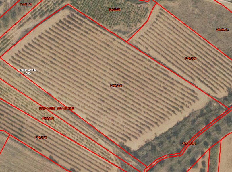
- 100% Commercial Agricultural Production
SIOSE label= PAGRI
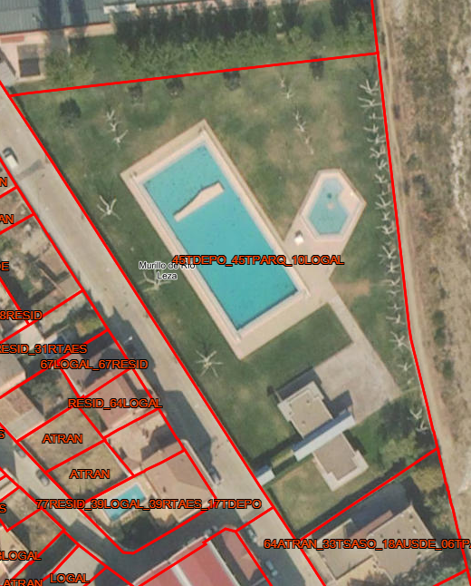
- 45% Sport
- 45% Park
- 10% Catering
SIOSE Label= 45TDEPO_45TPARQ_10TREST
SIOSE Label
As in SIOSE AR, SIOSE polygons have one or a combination of several covers associated with their percentage of occupation (%) or presence of covers in the polygon, and a series of attributes depending on the type of cover. Information on covers, percentages and attributes are represented in the same way as in the SIOSE AR label.
The differences with the traditional SIOSE AR are minimal, the cover label allows nesting of covers within each other by means of parentheses and introduces the concept of predefined composite classes.
The Label is a code that indicates what type of cover a SIOSE polygon has by means of cover labels and attributes represented by two or three letters, always reaching the last level of photo-interpretation of covers. These labels are summarised in the pdf document "Covers_Attributes_SIOSE.pdf".
Cover Labels
- Simple cover
It is represented by a label containing 3 capital letters. Each label is accompanied by two digits to indicate its percentage of occupation within the polygon or composite cover to which it belongs.
In the case of polygons with 100% simple cover, the value 100% is ignored and is only indicated by its 3 capital letters.
EXAMPLE:
100% Forest tree / Broadleaved / Deciduous.
SIOSE label= FDC - Composite/non-defined composite cover
The first label is a letter indicating the "SpatialDistribution" attribute of the covers in the composite, which are association ("A"), regular mosaic ("R") and irregular mosaic ("I").
It is followed by a bracket "( )", inside which are the labels of all the covers (simple and/or composite) of which it is composed, separated by an underscore "_" and two digits indicating the percentage of occupation within the polygon or the composite to which it belongs. Successive brackets will be opened within the first bracket as it contains many composite covers.
EXAMPLE :
100% Composite cover in "Association" made up of several single classes:- 45% scrubland.
- 35% Conífers
- 10% Grassland
- 10% Rock outcrops and crags
SIOSE label= A(45MTR_35CNF_10PST_10ARR) - Predefined composite cover
These are labelled in the same way as the non-predefined ones, except that the first label, before the brackets, does not indicate the attribute "spatialDistribution" but corresponds to the label of the predefined composite in question.
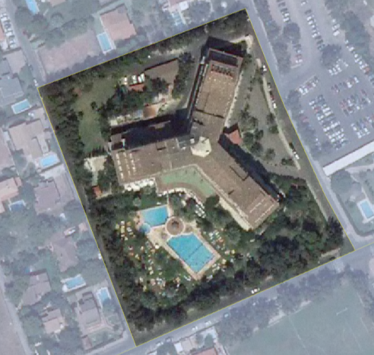 EXAMPLE:
100% predefined composite cover "Hotel Complex" consisting of the following single covers:
- 35% Building with the attribute "isolated block".
- 55% Green area
- 10% Roads
- 5% Artificial water sheet.
SIOSE=TCH label (35EDFea_55ZAU_10VAP_05LAA)
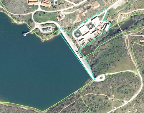 EXAMPLE:
100% predefined composite cover "Hotel Complex" consisting of the following single covers:
- 25% of buildings between dividing walls
- 25% of roads, car parks and pedestrian areas
- 35% of other types of buildings
- 15% of artificial green areas
SIOSE=NHD label (35OCT_25EDFem_25VAP_15ZAU)
Attribute Labels
These are indicated by two lower case letters following the cover to which they are assigned, except in the case of non-predefined composites where the attribute "SpatialDistribution" must be assigned.
MORE EXAMPLES:
100% Grassland with the attribute "firebreak function".
SIOSE label= PSTfc
100% composite cover in "Regular Mosaic" of 50% simple cover Herbaceous crop with the attribute "irrigated-irrigated" and 50% predefined composite cover "camping" composed in turn of: 70% unbuilt land, 15% building, attribute "isolated building", 10% artificial green area and urban trees and 5% sheet of water.
SIOSE label= R(50CHLrr_50TCG(70SNE_15EDFea_10ZAU_05LAA))
The SIOSE data model and the SIOSE sign are described in detail in the technical documentation of the project, in the "Documentation" section.


