Overview
One of the main objectives of the High Resolution SIOSE is to integrate the information from the land cover and land use databases of different Spanish public administrations at the national and regional level. After several versions of the project and taking into account the new land cover and land use needs of the main national and European users who demand data with greater geometric, thematic and temporal detail, a new production strategy has been developed that is more focused on data integration than on photo-interpretation. It structures the land cover and land use information in total harmony with other sets of geographic reference information that are essential for the State and the Autonomous Communities.
The High Resolution SIOSE is a new information system built by the integration of high detail geospatial sources, and its main objective is the integration, harmonisation and homogenisation of the aforementioned sources in order to continue to be a reference product in land cover and land use in Spain.
SIOSE AR image
The High Resolution SIOSE is part of the National Plan for Territory Observation (PNOT) and is a cooperative and decentralised project between the General State Administration and the autonomous communities, coordinated by the National Geographic Institute.
Its main characteristics include the following:
- Cooperative productive scheme between the General State Administration and the autonomous communities.
- High level of automation in the integration of reference sources, which allows for objectivity, cost reduction, more frequent updating and maintenance of responsible geometries and themes.
- Continuation of the philosophy of a SIOSE object-oriented data model or the European data model Copernicus EAGLE.
- Highest possible resolution from reference sources
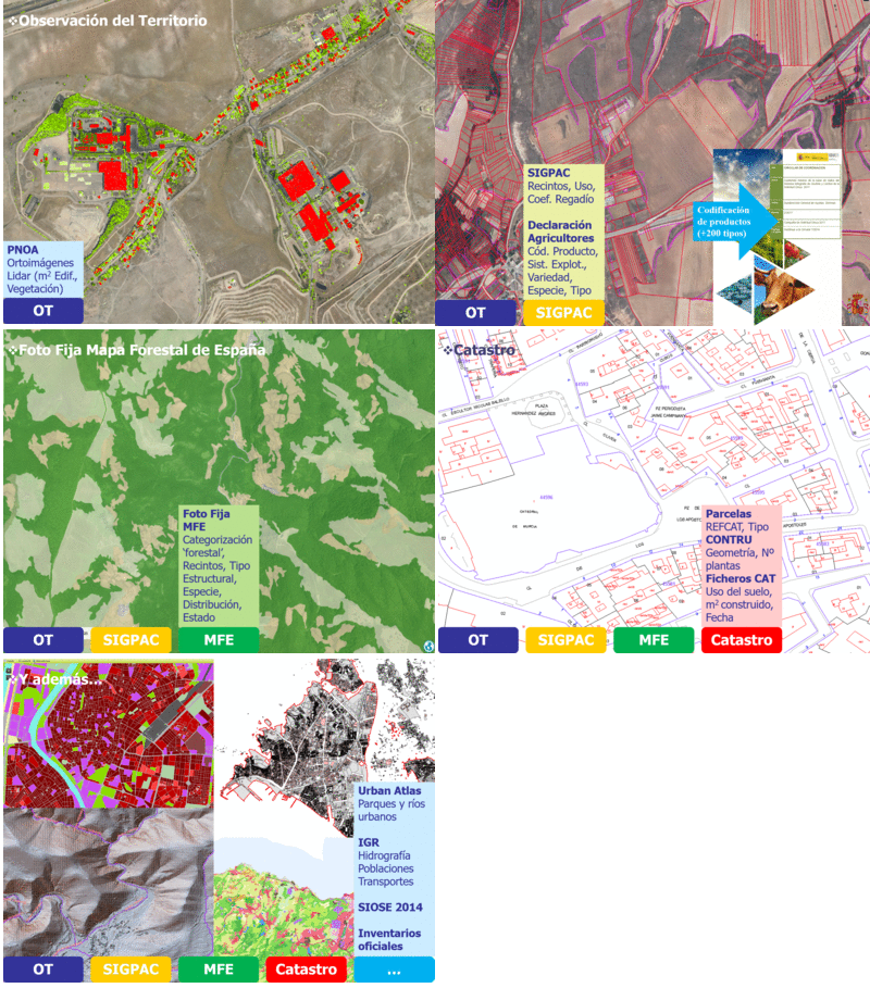
The main geometrical reference source is the Cadastre, from which the delimitation of plots and buildings is integrated. Cadastral parcels can be subdivided internally according to other agricultural or natural reference geometries, which are discussed below.
As main thematic reference sources of thematic information there are three different areas:
- Urban environments: Cadastre (General Directorate of Cadastre, Navarre and Provincial Councils of Álava, Guipúzcoa and Vizcaya), National Topographic Base BTN25 and information derived from observation of the territory, such as LiDAR data of buildings.
- Agricultural environments: SIGPAC, Farmers' Declaration.
- Natural environments: SIGPAC, still photo of the Spanish Forest Map and information derived from land observation such as LiDAR (by default, national data from the PNOA project are used).
- Regional data.
Additional geometric or thematic sources can also be found:
- Previous versions of SIOSE
- Geographic Reference Information of the National Geographic Institute of Hydrography, Transport and Population Network.
- Copernicus Land Monitoring Service products
- Other official inventories, topographic or thematic national or regional databases.
The latest available versions of the sources, adjusted to the SIOSE AR reference date, will always be used.

SIOSE AR Sources of Information
It is important to mention that the remote observation sources contemplated in the National Plan for Territory Observation (satellite images, PNOA orthoimages and PNOA LiDAR) and other earth observation initiatives such as the Copernicus Programme are essential for obtaining the High Resolution SIOSE, as they serve as the basis for capturing a large amount of the previously listed national and regional public data; they are fundamental for the visual revision phase of the High Resolution SIOSE.